FrankH.
Member
I can't avoid commenting any longer. This project is interesting, perhaps important, perhaps overdue.
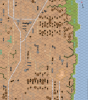
One thing is blocking me from getting too interested, however. I discovered the alignment of the Red October maps to the Red Barricades maps are not accurate. There is about a 5 degree twist to the RO maps. Undoubtedly the idea, the reason, was to make the road networks line up into a straight run all the way through the two factory areas. As far as I know, this is unnecessary, though someone potentially be able to explain it to me.
If the maps alignment issue cannot be corrected I don't see the point of going forward, south that is. Either redo the RO maps, or (less desirable) incorporate some kind of a 5 degree wedge connector map section between the RB and RO maps.