Rocket-Man
Space is only 100Km up
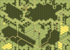
SSR 2 for Scenario ASL 48 Toujours L'Audace states that:
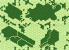
A literal reading of that sentence would indicate that all terrain bounded by the printed hills on the maps are treated as woods and all other terrain (including all woods hexes not on a hill) are open ground. But looking at the map posted on the ASL Scenario Archives shows that the person who made that map read the SSR to mean that all terrain except existing woods hexes are open ground (some wall hexsides were also left in on the map, I'm guessing in error). See the first image below for this interpretation of the SSR.
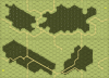
If the SSR is read to mean the only non open ground terrain on the map is woods that us bounded by the printed hill masses and all all other terrain features (including woods hexes not already on hills) therein, except roads, do not exist and are ignored, the map would look like the second image below.
My initial reading of the SSR was the same as whoever made the Scenario Archive map, but I wanted to see what others had to say about it. I am making overlays for Maps 2 and 11 for this scenario that I hope will be included with the map files in the future and I want to get it right.
2. All hill hexes on both boards are considered ground-level woods; outline of these woods conforms to the outline of the printed hill masses (including the cliff faces). All other terrain features (including the entire 11 P8-P9 hedge) therein, except roads, do not exist and are ignored.
A literal reading of that sentence would indicate that all terrain bounded by the printed hills on the maps are treated as woods and all other terrain (including all woods hexes not on a hill) are open ground. But looking at the map posted on the ASL Scenario Archives shows that the person who made that map read the SSR to mean that all terrain except existing woods hexes are open ground (some wall hexsides were also left in on the map, I'm guessing in error). See the first image below for this interpretation of the SSR.
If the SSR is read to mean the only non open ground terrain on the map is woods that us bounded by the printed hill masses and all all other terrain features (including woods hexes not already on hills) therein, except roads, do not exist and are ignored, the map would look like the second image below.
My initial reading of the SSR was the same as whoever made the Scenario Archive map, but I wanted to see what others had to say about it. I am making overlays for Maps 2 and 11 for this scenario that I hope will be included with the map files in the future and I want to get it right.
") ... Thank you so much !!!
... Thank you so much !!!