The Purist
Elder Member
- Joined
- Aug 16, 2004
- Messages
- 2,917
- Reaction score
- 1,480
- Location
- In my castle by the sea, Trochu, AB
- First name
- Gerry
- Country
-

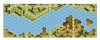
With 80(?) standard boards and 11 of the #a/b configurations ASL can represent most terrain types with perhaps the exception of steep sided valleys and other escarpments that would have roads that 'switchback' or have long exposed descents along the slope. We do have board 25 and the Escarpment overlay from WoA/FKaC but the terrain depicted is decidedly north African and does not necessarily translate well to European terrain.
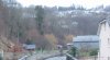
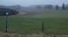
There are a number of situation is Europe where this could add to the scenario 'cache'. For example, the Don west of Stalingrad or the west bank of the Dnepr river had areas where the west banks had a significant height advantage over the eastern bank. In such cases 'level 0' above and below the escarpment would very much follow the pattern found on Board 25 and the Esc overlay. In Italy, the Carpathians, near the Roer, etc., the terrain near the bottom of river major valleys often had fairly wide flood plains that possessed villages, farms, vineyards, orchards and so on.
With the current board selection, scenario designers either need to make do with Boards 25, use other hill maps and 'hex numbers 6+, or the heights can be ignored and the troops enter from board edges already down at the 'new' level 0.
So,... the questions for the players are as follows:
1) Is board 25 and it overlay sufficient to represent river valleys or "steppe changes"? Would changing crag and scrub to woods and hammada to brush be acceptable to attract players to a scenario?
Or,
2) Is the colour difference too much for aesthetics and players prefer to use other options mentioned above (other hill maps, entry at valley bottom)?
Finally,
3) Should MMP (or a TPP) perhaps design two or three "European escarpment" boards (or overlays), perhaps two standard and one a/b, that could be used to show abrupt elevation changes near river valleys?
Cheers.
Last edited: