Honza
The Art Of Wargames
- Joined
- Dec 30, 2005
- Messages
- 13,914
- Reaction score
- 2,662
- Location
- Oxfordshire
- First name
- Jan
- Country
-

Yup....orchards ought to be out of season.
By the time the fighting hit the RB area there were very few trees left intact, mere splintered trunks at most, I feel the one thing that most people fail to understand or comprehend is the shear scale of destruction that happened in that city, it was 85%+ flattened, not smashed up a bit, but flattened, whole districts with not even a curb stone intact! central Grad was gutted and again a lot of stuff leveled or reduced to one or two walls standing.It has always bothered me that Orchards are in season in October on the RB map. I've never seen a picture with a leaf on a tree from this time period. I think Orchards should be treated as out of season on the RB maps. I will defer to the historians among us as to whether this is a valid observation or if I'm totally off my rocker.
Technically true but I think the Gavutu-Tanambogo map would be less well received if the Palm Trees used Orchard graphics. One of the allure of the HASL maps is the freedom to depict the terrain in its historical state rather than its geomorphic abstraction.The terrain depiction for orchards in or out of season is the same in the rules, it is only in Vasl that the terrain depiction for out of season orchards has been invented.
True, but to redraw the map with out of season orchards would also require a new RB SSR to state that Orchards are out of season, so this exercise now becomes more than just redoing a map, its redoing the module. In any case if we are talking about a Vasl map the orchards can be made out of season at the click of a button on the existing map.Technically true but I think the Gavutu-Tanambogo map would be less well received if the Palm Trees used Orchard graphics. One of the allure of the HASL maps is the freedom to depict the terrain in its historical state rather than its geomorphic abstraction.
Well yes, one would follow the other. I'm merely pointing out that if one does define the Orchards to be OoS, then the community would probably expect the map graphic to match.True, but to redraw the map with out of season orchards would also require a new RB SSR to state that Orchards are out of season, so this exercise now becomes more than just redoing a map, its redoing the module.
Budapest was not levelled like Stalingrad was, look at the aerial photographs of the two, the 'Grad' was as stated pretty much flattened, around the Factory sector there was hardly a blade of grass left standing let alone a tree.There are out-of-season orchards on the Festung Budapest maps. There's no reason the redone RB map couldn't/shouldn't do the same.
I wasn't arguing that there should or shouldn't be orchards. Just saying that there's no reason orchards couldn't be rendered as out of season. It's been done, on official HASL maps, was my point. Not comparing Budapest to Stalingrad in any way.Budapest was not levelled like Stalingrad was, look at the aerial photographs of the two, the 'Grad' was as stated pretty much flattened, around the Factory sector there was hardly a blade of grass left standing let alone a tree.
Agree, with you, just when the map is repainted d it should have no orchards etc what so ever, they simply did not exists in the area once the fighting had reached it.I wasn't arguing that there should or shouldn't be orchards. Just saying that there's no reason orchards couldn't be rendered as out of season. It's been done, on official HASL maps, was my point. Not comparing Budapest to Stalingrad in any way.
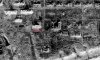
The picture is dated just before Hubertus so pre 11th November 1942.I believe Perry's picture is dated in the spring of 43. The devastation shown is after the massive Russian arty barrages in mid January as the red army advanced up from the south east corner. One building discrepancy is the M22 ish area factory (dont have my map handy), it is 3 buildings according to Island of Fire. Some of the stone buildings east of the bread factory were roofless like VotG.
I think a more contentious issue is the lvl of certain buildings. Going from some aerial photos its easy to see that the Comm's House was nowhere nearly as tall as other buildings, some of which were clearly 4-5 floors high, leaving shadows double or more than that cast by the Comm's House. All of the factories that are in a photo containing the Comm's House cast a longer shadow. This is probably something that would cause balance issues.
")
That is seriously dilapidated terrain. It was a whole lot more intact in Oct. 42.The photo appears to be part of this aerial, http://www.wwii-photos-maps.com/stalingradaerialscans/GX2839SD/slides/GX2839SD-558.html, which was taken in march of 43. Us Canucks dont consider the ground floor a storey so to us its a 2 story building and elevators are labeled G, 1, 2
The whole area pre Hubertus is asu see it in the photographs, the only main changers. Hubertus early 43 was simply more shell holes, very remain buildings were changed except the top floor of the commissary house was pretty much levelled.The photo appears to be part of this aerial, http://www.wwii-photos-maps.com/stalingradaerialscans/GX2839SD/slides/GX2839SD-558.html, which was taken in march of 43. Us Canucks dont consider the ground floor a storey so to us its a 2 story building and elevators are labeled G, 1, 2