We had problems finding the roads on the Schmidt map in Kommerscheidt. Today the road layout is not the same as shown on the map.
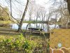
the pond in O19 as seen from O20 was a good point of reference.
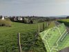
View of Kommerscheidt from approx. hex X17. The road on the right does not exist on the Bounding Fire map.
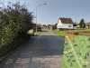
The streets of Kommerscheidt as seen from approx. hex V9
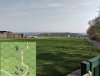
The edge of the board - this is the Kall trail as seen from hex X4.
the pond in O19 as seen from O20 was a good point of reference.
View of Kommerscheidt from approx. hex X17. The road on the right does not exist on the Bounding Fire map.
The streets of Kommerscheidt as seen from approx. hex V9
The edge of the board - this is the Kall trail as seen from hex X4.
Last edited: