One-sided Sunk/Elevated Roads

Michael Dorosh

der Spieß des Forums
Joined
Feb 6, 2004
Messages
15,733
Reaction score
2,765
Location
Calgary, AB
First name
Michael
Country
llCanada
This is an excellent example of a 'cut' made by engineers to lessen the slope of a road that climbs over a hill or one that skirts the shoulder of a hill. I have no problem picturing this type of terrain. In fact, I could walk the four minutes up to the clubhouse on the town's golf course and take a picture of this exact terrain type (slope "up" one side of the road and another "down" the opposite side).

Excellent idea.
You couldn't swing a dead cat west of our city without hitting a cut like this, eh?

17095
 
Last edited:

RandyT0001

Elder Member
Staff member
Administrator
Moderator
Joined
Dec 5, 2016
Messages
1,055
Reaction score
1,273
Location
Memphis, TN
First name
Cary
Country
llUnited States
You couldn't swing a dead cat west of our city without hitting a cut like this, eh?

View attachment 17095
I would see this more as a double crest line, like 15P3 to Q4. Generally impassable to vehicles but passable to infantry and cavalry at a substantial movement cost.
17098
 

RandyT0001

Elder Member
Staff member
Administrator
Moderator
Joined
Dec 5, 2016
Messages
1,055
Reaction score
1,273
Location
Memphis, TN
First name
Cary
Country
llUnited States
You could get a vehicle up that slope. Especially if it didn't belong to you. :)
Modern vehicle, yes. Street cycle, maybe. What World War 2 tank, half-track, armored car would you say is capable of driving up the slope?

As a commander, would you task your tanks, etc. to assault up the hill or try to go around?

Would the vehicle's ground pressure be a factor?

What about climbing when the hill is soaked in gasoline?


;)
 

Tuomo

Keeper of the Funk
Joined
Feb 10, 2003
Messages
4,654
Reaction score
5,540
Location
Rock Bottom
Country
llUnited States
I would see this more as a double crest line, like 15P3 to Q4. Generally impassable to vehicles but passable to infantry and cavalry at a substantial movement cost.
But that would require you to put that second hill in there, and sometimes that's not good.

I understand that Cliffs function similarly, but not exactly the same as the proposal since infantry can only Climb to get up a cliff.

Sounds like a collective "meh", which surprises and disappoints me, but hey, that's why I asked. Ya narrow-minded so-and-so's.
 

Michael Dorosh

der Spieß des Forums
Joined
Feb 6, 2004
Messages
15,733
Reaction score
2,765
Location
Calgary, AB
First name
Michael
Country
llCanada
Modern vehicle, yes. Street cycle, maybe. What World War 2 tank, half-track, armored car would you say is capable of driving up the slope?

;)
LOL to the BOB reference.

Check out Longstop Hill in Tunisia - the Churchills surprised the hell out of the Germans by going up "impassable" slopes. Certainly a slope like the one in the pic would be zero problem for a Jeep or Universal Carrier, naturally depending on the ground cover.

Might need to SSR track grousers for the tanks if this video is any indication....

 
Last edited:

RandyT0001

Elder Member
Staff member
Administrator
Moderator
Joined
Dec 5, 2016
Messages
1,055
Reaction score
1,273
Location
Memphis, TN
First name
Cary
Country
llUnited States
But that would require you to put that second hill in there, and sometimes that's not good.

I understand that Cliffs function similarly, but not exactly the same as the proposal since infantry can only Climb to get up a cliff.

Sounds like a collective "meh", which surprises and disappoints me, but hey, that's why I asked. Ya narrow-minded so-and-so's.
I was describing Michael's hill not suggesting that you use a double hill.

As I stated here:

The cliff hex side depiction can be used to prevent vehicle movement and adding the SSR to grant infantry special ability to climb the hill with out Climb or scaling seem to directly address the problem.
 

The Purist

Elder Member
Joined
Aug 16, 2004
Messages
2,917
Reaction score
1,480
Location
In my castle by the sea, Trochu, AB
First name
Gerry
Country
llCanada
Sounds like a collective "meh", which surprises and disappoints me, but hey, that's why I asked. Ya narrow-minded so-and-so's.
DON'T LISTEN TO THE NAY SAYERS, TOM!

Your idea is one of the most original ideas since the a/b maps. It should be developed further.

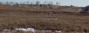
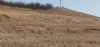
As I mentioned above I can stand at the edge of the parking lot at our local GC clubhouse and see this:

17109


Looking down always makes perspective more tricky and this shot is not zoomed in at all (a vehicle in the shot would have helped). The bottom of the coulee (Balka) is probably two to three levels below the 'hill I am standing on (its actually level 0 terrain, or the same general elevation of the surrounding prairie).

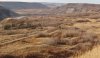
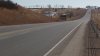
If I drop down to the spot where the two streams meet mid-frame and look up, I see this:


17110

I was standing by the telephone pole at the top for the first pic. The road might even be considered "elevated" from the perspective of anyone trying to climb the slope from the coulee bottom to the road. A person who is fit can run up to the road in about 20-30 seconds, a minute or so more to the top. Definite minimum move terrain.

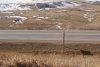
Looking right from the coulee bottom you can better see the effect of the slope from the hill to the road to the coulee bottom.

17111

Standing on the road, level 1 hill with sunken road embankment to the left as the road slopes down into the coulee. This could be classed an an elevated road as a culvert carries the stream eastward under the road below.


17115
 

Attachments

Last edited:

Michael Dorosh

der Spieß des Forums
Joined
Feb 6, 2004
Messages
15,733
Reaction score
2,765
Location
Calgary, AB
First name
Michael
Country
llCanada
Sounds like a collective "meh", which surprises and disappoints me, but hey, that's why I asked. Ya narrow-minded so-and-so's.
Honza used to start threads here, have people line up to agree with him, and then express his disappointment at the positive response. I'm starting to wonder if there's a name for that.
 

The Purist

Elder Member
Joined
Aug 16, 2004
Messages
2,917
Reaction score
1,480
Location
In my castle by the sea, Trochu, AB
First name
Gerry
Country
llCanada
Pah! I am always out trapesing around the area. I wear out hiking boots regularly. The town lies on the high ground between two drainage areas. The coulee pictured above comes in from the west and winds its around the south of the town (with higher, steeper and often wooded slopes) and then heads east again to meet the Ghostpine Creek that meanders through its own broad, shallow valley.

If you want a real piece of Steppe Terrain this feature is just 15 minutes east of town. There are some abrupt elevation changes involved:

17119
 
Last edited:

Michael Dorosh

der Spieß des Forums
Joined
Feb 6, 2004
Messages
15,733
Reaction score
2,765
Location
Calgary, AB
First name
Michael
Country
llCanada
We have plenty of nice balkas around here too. Just about everything really. If New Zealand ever fell into the sea you could milk the LOTR cash cow right here.
 

sswann

Elder Member
Joined
Jan 31, 2003
Messages
2,914
Reaction score
1,386
Location
Middle of Kansas
First name
Steven
Country
llUnited States
Showing pictures of US roads with gentle slopes is not a good example of Tom's drawing.
Instead go on-line and look at pictures of the Burma Road to China in 1943-45.
Make the map... Tom!
 

Actionjick

Forum Guru
Joined
Apr 23, 2020
Messages
7,589
Reaction score
5,085
Location
Kent, Ohio
First name
Darryl
Country
llUnited States
Pah! I am always out trapesing around the area. I wear out hiking boots regularly. The town lies on the high ground between two drainage areas. The coulee pictured above comes in from the west and winds its around the south of the town (with higher, steeper and often wooded slopes) and then heads east again to meet the Ghostpine Creek that meanders through its own broad, shallow valley.

If you want a real piece of Steppe Terrain this feature is just 15 minutes east of town. There are some abrupt elevation changes involved:

View attachment 17119
And here I thought coulee was a type of sauce! 😉🤤
 

Tuomo

Keeper of the Funk
Joined
Feb 10, 2003
Messages
4,654
Reaction score
5,540
Location
Rock Bottom
Country
llUnited States
Actually, Steve, it's easy for me to envision these things since I live in Colorado. Oftentimes you wonder why they cut the road into the side of the hill, vs going THROUGH the hill or around the hill.

Fortunately my days of driving from Denver to Vail to pick up my kids for a weekend are over. What a terrible reason to drive through beautiful country.
 

Gordon

Forum Guru
Joined
Apr 6, 2017
Messages
2,491
Reaction score
2,942
Country
llUnited States
I think the important thing is that the terrain feature has to seem necessary given the other terrain around it. Often geoboard terrain seems to be somewhat arbitrary. There needs to be a reason the road cut into the side of the hill rather than going over it or around it.
 

bprobst

Elder Member
Joined
Oct 31, 2003
Messages
2,535
Reaction score
1,441
Location
Melbourne, Australia
First name
Bruce
Country
llAustralia
As a minor data point, the Japanese at Kohima were astonished to the point of panic when the British tanks (Grants, I believe) drove up the side of the hill to get into their position. Nobody -- including the tank drivers! -- thought it could be done.

We ASL players with perfect knowledge of what is and isn't possible are difficult to astonish in the same way.
 

Nineteen Kilo

Senior Member
Joined
Nov 24, 2005
Messages
795
Reaction score
323
Location
Fair Oaks CA
Country
llUnited States
If you really wanted to bring the game to a halt you'd add some Kampfgruppe Peiper Slope Hexsides on the the "un-elevated" hexside away from cutout portion of the hill.
 
Top