LFT's new HASL map.

Russ Isaia

Member
Joined
Oct 23, 2015
Messages
566
Reaction score
148
Country
llUnited States
No, Russ, that brown feature is a Plowed Field. And that water in the SW corner is just a section of a river/canal.

Tom
Then mea culpa, an unfortunate choice of illustration. How about this?

18648
 

Xavier 658

LFT Magazine Editor
Joined
Feb 12, 2003
Messages
1,408
Reaction score
1,632
Location
Margny les Compiègne, France
First name
Xavier
Country
llSpain
Hi Russ,

P.S. I am in awe of anyone with the technical skill, knowledge, and experience to produce work of this high quality. Thank you.
Have you ever drawn an ASL map? Or any other map that needs a hex grid to be applied on it?

Tom has done a great job with Inor's map, and if you don't like it, this is fine, there's no need for you to use it.

X

PS: welcome.
 

jyoung

Senior Member
Joined
Feb 19, 2020
Messages
382
Reaction score
453
Country
llAustralia
Can't wait for it to turn up in my mailbox.
I hate waiting :mad:
 

Russ Isaia

Member
Joined
Oct 23, 2015
Messages
566
Reaction score
148
Country
llUnited States
Hi Russ,


Have you ever drawn an ASL map? Or any other map that needs a hex grid to be applied on it?

Tom has done a great job with Inor's map, and if you don't like it, this is fine, there's no need for you to use it.

X

PS: welcome.
As my post made clear (I thought), I have not made a game map of any sort. That should not bar me from having an opinion on what I like and don't like, however. I can't replicate the paintings of Picasso: that should not mean I can't opine that they suck (my apologies to any admirers of his work but I prefer more realism in my art).

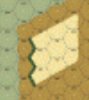
As to boardgame mapmaking, it is inherently a compromise between realism and abstraction. Some degree of abstraction is imposed by the tools and technologies of graphics and display but these days, I believe, not much. In my opinion the natural terrain of this board, the elevation crest lines and woodland edges for example, is too abstracted: they regularly intersect the hexsides of their hexes at the same points. That gives a linear appearance to neighboring hexes. As God does not build in straight lines, that also gives the board an "unnatural" appearance that I don't like as much as I would something more natural.

I never let perfect become the enemy of good (or in this case, the very good). So, if I don't buy this product, it will not be for this reason. Just kidding, of course: as I'm a sucker for anything early war I'm in when it becomes available in the States.

P.S. I don't believe the hexagonal grid has not material effect on the VASL mapmaking process. It's a previously prepared graphics layer available for download to which one adds other handpainted layers of various terrain features, for example, layers of the roads, woods, hills and brush. I may not have done a map, but I have a general understanding of how it is done. And you can too: just download Ye Old Booke of VASL Mapmaking Secrets. Page 7 shows the layering involved.
 

Maurizizio

Senior Member
Joined
Jan 18, 2018
Messages
381
Reaction score
400
Location
Florida
First name
Maurizio
Country
llUnited States
That should not bar me from having an opinion on what I like and don't like, however. I can't replicate the paintings of Picasso: that should not mean I can't opine that they suck (my apologies to any admirers of his work but I prefer more realism in my art).
Well, I think that having an opinion means "I don't like", while saying "it sucks" it is more an "insulting free statement" .... In my opinion :LOL:😱😬
 

Russ Isaia

Member
Joined
Oct 23, 2015
Messages
566
Reaction score
148
Country
llUnited States
Well, I think that having an opinion means "I don't like", while saying "it sucks" it is more an "insulting free statement" .... In my opinion :LOL:😱😬
Naw, a difference of degree only. "[Opining] that it sucks" just means that "I really really don't like it." ;)
 

lionelc62

Senior Member
Joined
Nov 16, 2007
Messages
410
Reaction score
452
Location
Northern France
First name
Lionel
Country
llFrance
In fact, the map has been drawn from a 1950 map of the area (with some modifications to take into account the change since 1940). The hill reflects the elevations depicted on this map. We went on the battlefield with a copy of the first draft of the map and we found that it was pretty accurate (we changed 2-3 hexes following this visit).
And Tom did a great job to make it beautiful.


Regards
lionel
 

Tooz

Elder Member
Joined
Sep 17, 2004
Messages
1,338
Reaction score
1,063
Location
York, PA
Country
llUnited States
This map will make for a good late war SASL CG too.
There have been some good scenarios designed on HASL maps that were outside the theaters of which the map was designed. This map could easily be used to depict terrain in many scenarios which feature hill assaults. You do not need to use the whole map. I'm thinking Italy, Tunisia, Balkans and Caucasus here.
 

Brad M-V

Senior Member
Joined
Jul 20, 2012
Messages
646
Reaction score
330
Location
British Columbia
Country
llCanada
Naw, a difference of degree only. "[Opining] that it sucks" just means that "I really really don't like it." ;)
By ignoring the word insult and it's fellow synonyms, it could really really free up the court system, too;

offend · give/cause offense to · affront · abuse · be rude to · call someone names · slight · disparage · discredit · libel · slander · malign · defame · denigrate · cast aspersions on · impugn · slur · revile · calumniate · hurt · hurt someone's feelings · mortify · humiliate · wound · snub · rebuff · spurn · shun · treat disrespectfully · ignore · cut dead · give someone the cold-shoulder · turn one's back on · bad-mouth · slag off · trash-talk · sledge · asperse · derogate · miscall · abusive · rude · vulgar · offensive · wounding · mortifying · humiliating · disparaging · belittle · derogatory · depreciating · deprecatory · disrespectful · denigrator · uncomplimentary · pejorative · vituperative · disdainful · derisive · scornful · contemptuous · defamatory · slanderous · libelous · scurrilous · blasphemous · discrediting · bitchy · catty · contumelious.

You might be onto something here... ;-)
 

Robin Reeve

The Swiss Moron
Staff member
Moderator
Joined
Jul 26, 2003
Messages
19,638
Reaction score
5,621
Location
St-Légier
First name
Robin
Country
llSwitzerland
Since the triangular buildings and 60° angled roads of Board 1 (simulating... Stalingrad!), I have accepted that the hexgrid imposed abstracted terrain - which is more perceptible at the low scale of SL/ASL.
 

Russ Isaia

Member
Joined
Oct 23, 2015
Messages
566
Reaction score
148
Country
llUnited States
Since the triangular buildings and 60° angled roads of Board 1 (simulating... Stalingrad!), I have accepted that the hexgrid imposed abstracted terrain - which is more perceptible at the low scale of SL/ASL.
I don't think the hexgrid has much to apologize for except hedges, walls and maybe cliffs (and then only because rules such as Wall Advantage, PBF vs. TPBF, no entry of enemy-occupied hexes), etc. might have a difficult time with hedges, walls or cliffs that were within a hex, rather than on its hexside(s)). Nor is any apology needed from anyone when regularized buildings, roads and other manmade terrain are employed: that is the way man builds, both on the ground and on a representation of the ground (i.e., a map). It's the natural terrain where the mapmaker has to be careful not to regularize the terrain too much or risk a less pleasing result. IMO of course.

BTW, sure wish we could have hedges interior to a hex. The Chateau on Board 6 never made sense to me without extensive formal gardens at least to the rear instead of those orchards (so plebeian!).
 

Robin Reeve

The Swiss Moron
Staff member
Moderator
Joined
Jul 26, 2003
Messages
19,638
Reaction score
5,621
Location
St-Légier
First name
Robin
Country
llSwitzerland
Board 6 is so wrong on many aspects.
The Chateau is about 200 meters wide, the gardens are huge (you have the impression that the 40 meters wide woods represent a tree each).
Only nostalgia (recalling the CoD famed scenarios) saves it.
 

Russ Isaia

Member
Joined
Oct 23, 2015
Messages
566
Reaction score
148
Country
llUnited States
Board 6 is so wrong on many aspects.
The Chateau is about 200 meters wide, the gardens are huge (you have the impression that the 40 meters wide woods represent a tree each).
Only nostalgia (recalling the CoD famed scenarios) saves it.
Not so. I am thinking more along the lines of the formal gardens seen in the rear of the great houses of Regency England, with manicured trees and hedges, fountains and statutory on acres of land. Forty meter wide regularly spaced copses of trees is not enough. But maybe that was not so much a Continental thing by 1940.
 

Thunderchief

Elder Member
Joined
Oct 16, 2003
Messages
1,207
Reaction score
741
Location
Canberra, Australia
Country
llAustralia
Board 6 is so wrong on many aspects.
The Chateau is about 200 meters wide, the gardens are huge (you have the impression that the 40 meters wide woods represent a tree each).
Only nostalgia (recalling the CoD famed scenarios) saves it.
Good use of overlays helps the appearance/"realism" of bd6.
 

Cpl Uhl

Senior Member
Joined
Dec 2, 2007
Messages
866
Reaction score
478
Location
Brussels, Belgium
Country
llUnited States
In fact, the map has been drawn from a 1950 map of the area (with some modifications to take into account the change since 1940). The hill reflects the elevations depicted on this map. We went on the battlefield with a copy of the first draft of the map and we found that it was pretty accurate (we changed 2-3 hexes following this visit).
And Tom did a great job to make it beautiful.


Regards
lionel
Wait, did you say "we went on the battlefield"? Toktong is in N Korea. Do tell us about that visit please.
 
Top