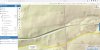
The maps seem to use LIDAR data.
These type of maps (not with any military units of course) are available for parts of Germany with incredible detail (you can discern WW2 era trenches and craters in areas that are today overgrown forests.
A couple of years ago, I posted about that.
Current link to such maps for Nordrhein-Westfalen (one of the German states) is:
TIM-online ist eine Internet-Anwendung des Landes Nordrhein-Westfalen zur Darstellung der Geobasisdaten der Vermessungs- und Katasterverwaltung NRW sowie für die Meldung von Abweichungen zwischen präsentierter digitaler Kartendarstellung und der Örtlichkeit.
www.tim-online.nrw.de
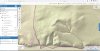
This is an example of a strech of Reichswald on the German/Dutch border.
You can see WW1 fortifications (the rectangular trenches) and WW2 fortifications (a bit further away from the border).
The website allows to to freely zoom in and out, blend over current modern maps over the LIDAR ones. Even historical maps of various times can be used.
If you want to reserach scenario terrain for, say, Operation veritable, the Rees HASL, and things like that, this site (although in German) is a true boon.
von Marwitz
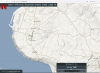
 map.project44.ca