The map images are not stored in the module (.vmod) file. They are stored in board files, which do not have extensions. You may be thinking of the game files, which can be saved with any extension, and I am guessing you are saving them with vsl. I use .vsav. The saved game files do not contain the maps themselves. They contain the names of the maps. The maps are loaded from the board files. You can print the map from the board files, but that will not show any features of the on-going game, nor is it possible to generate an image with multiple maps as a single image, if that is what you are aiming to do, without using some other program.
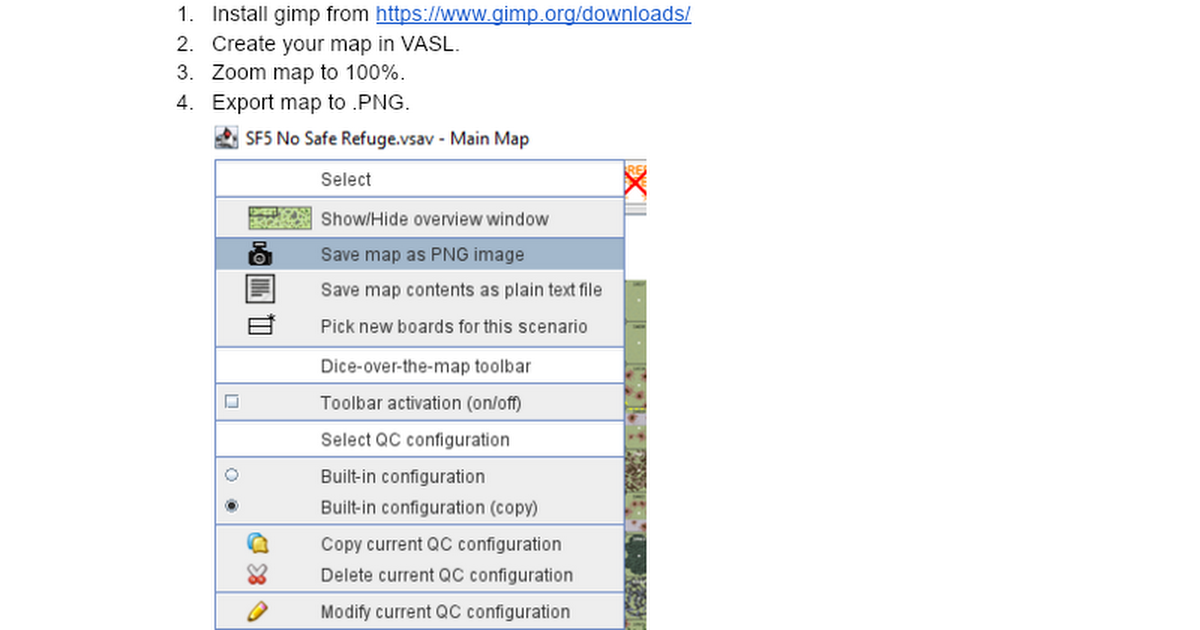
vasl exports .png files, and I believe .png files have a definite idea of how big they are physically. A two-map-row map exported to .png while viewed at zoom 100% is exported at 300 dpi, is 2600 x 2090 pixels, and will print at size 8.667 x 6.967 inches, including a 400 pixel (1.33 inch) white border around the maps. The driver and/or the program you print with will make sure that it actually prints at that size, unless you aren't paying attention and leave a checkbox on that says "fit to page size" or something similar. A map exported while at zoom 50% is exported at 300 dpi and is 1300 x 1045 pixels and 4.33 x 3.483 inches. Again if you print it at its natural size, It will appear on paper as that size (in inches). The printer driver will convert the image dpi and number of pixels to the equivalent on the printer, no matter how printer native dpi varies from dpi in the .png file.
Some image formats do not store the physical size (or dpi) inside themselves (or perhaps some programs don't insert that information in them). In those cases images printed on one printer may have a different size than ones printed on a different printer, but the vasl images do have the dpi information stored in them, so I believe that probably all printers will print the images exported from vasl at the same size (again, barring some other program or driver resizing it).
Depending on what you are aiming to do, one problem may be that the vasl board files are not the same ratio length to width as the true maps. vasl maps are 1800 x 645 pixels. By my measurement physical maps are 8 x 21 15⁄16 inches (I got a range of measures from the different, bad rulers I own; you may want to find a really good ruler to get more precise numbers). If you compare the length to width ratios of physical to vasl you will see they disagree by about 1.5%. So when you zoom to the correct width (372.1% seems to be a number that works to get the right width), the length will be off and vice versa. If your goal is to produce maps that will be compatible with physical maps, you must scale the width and the length independently. There is no vasl zoom level that will produce compatible maps. You should be able to punch numbers into a spreadsheet to get the correct x and y scaling, however. If your goal is to print out maps that are a certain size across but are not concerned with compatibility with physical maps then you should be able to punch in numbers and produce maps that are whatever size you want using either vasl zoom or some other program for scaling.
JR