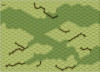
How many different boards do you think it would take to properly and faithfully represent the balka type of terrain?I'm not a big fan of using boards where we need to pretend that one feature is either not there or is something else. I also don't like ugly overlays that might be technically functional, but look, well, ugly.
Making new boards isn't hard - the design work is easy, the cost is relatively inexpensive, and given that we don't need to buy any other components (we have all the counters and rules) - what's left to add to our collection than new boards? Not much, so let's do some new boards and do it right.
Attention Mapmakers: Soviet villages
- Thread starter Pitman
- Start date
Here is one example of what I'm talking about:
And here is another:

I estimate that we will need about 10 -15 new boards and use wadi overlays for the feeder gullies at the sharper points.
And here is another:
I estimate that we will need about 10 -15 new boards and use wadi overlays for the feeder gullies at the sharper points.
Tuomo
Keeper of the Funk
So that's pretty much a non-starter for any publisher, although you could probably get CH to buy into it because, hey, CH. IMO, the closest you can get to that these days is 3-4 boards in a module. Again IMO, it would have to be a pretty big subject (like Forgotten War) for MMP to do something like that, and I just don't see the great upswell of support for that (ie, it's not like Balka boards have been long recognized as an outstanding hole in the system and people can't wait for a treatment on that subject, but I could be wrong).I estimate that we will need about 10 -15 new boards and use wadi overlays for the feeder gullies at the sharper points.
So I'd think your best bet would be BFP or LFT, who have both shown the willingness to publish geo boards for areas like this. But again, I'd suggest cutting it down to 3-4 boards.
If you really want MMP to publish something like this, I would think you could do a credible job with a single Fort-style board published in an Action Pack or WO Pack. Sorry, but IMO that's the reality. I do think, though, that it could be done.
Michael Dorosh
der Spieß des Forums
- Joined
- Feb 6, 2004
- Messages
- 15,733
- Reaction score
- 2,765
- Location
- Calgary, AB
- First name
- Michael
- Country
-

When Tuomo says it can't be done, he means it can't be done by mere mortals.
A set of 10 or 15 solid scenarios would sweeten the prospective deal with any publisher...
A set of 10 or 15 solid scenarios would sweeten the prospective deal with any publisher...
DWPetros
Senior Member
- Joined
- Sep 27, 2016
- Messages
- 218
- Reaction score
- 502
- Country
-

I agree with Tom. 3- 4 would work. Piece of cake, eh Tom?How many different boards do you think it would take to properly and faithfully represent the balka type of terrain?
I agree with Tom that there is not a great demand for this new terrain. It is a minority of ASL players that favor desert and/or (fewer even for) steppe open field combat. Maybe, we can get two or (max) three scenario packs with 10 to 12 good, 'really fun for the typical non-steppe aficionado' scenarios for each one. (I am not in favor of working on this only to see CH and nobody but Ray, profit from it.)
I have five different outlined boards above. If you SSR that the full width level -1 board can be any board composed primarily of level 0 as its base level (ie not boards 2, 3, or other hill boards) you might get by with just four. However, if you allow that substitution why not just offer terrain substitution from the beginning, like I suggested using the river boards as mid section balka level -1 and overlays.I agree with Tom. 3- 4 would work. Piece of cake, eh Tom?
Tuomo
Keeper of the Funk
Now what? Profit?
Jeffrey D Myers
Senior Member
Tuomo = Prophet of the Funk (aka Balka)
jrv
Forum Guru
Next are the Map-Proof-Reading and Rules-Lawyering Phases. Note that on the ASOP there is no Profit Phase.Now what? Profit?
View attachment 5126
As far as I can tell none of those hexes is, by rule, a gully. Per B19.1 a gully is "a thin, meandering black line enclosed in a light brown background which, in turn, is enclosed in a dark green background." None of the hexes you draw have the black line. That is relatively harmless, but it would be nice to follow the rule if not too inconvenient. Recent MMP maps also seem to ignore the rule (e.g. boards 2a, 5a), so perhaps it is too late to follow the rules that strictly.
My other observation that is a bit more disconcerting is that there are several hexes where it is not easy to tell whether a gully hex at level -1 was intended. As best I can tell, by rule all of I18, J13, N17, T8, W12, Y19 and DD14 are all gully hexes at level -1. Some of the artwork seems a bit hesitant, however. In hexes I18 and T8 especially I am left feeling unsure that this was the intention because the artwork doesn't go very deeply into the hex. My suggestion would be that where a gully hex is intended the artwork should cross more than three-quarters of the hex, while if a gully is not intended the artwork should not include all three defining colors and it should cross less than a quarter of the hex. Gully hexes need not capture the hex center in artwork but the artwork should boldly assert that the hex is gully in that case.
If you intend any of the hexes I think are gully hexes at level -1 to be regular open ground hexes instead, I would suggest some alteration to the map. The standard rules don't seem to allow for a gully hexside across a crest line that doesn't connect between two gully hexes. In particular hexes 41H5, 2bBB3 & 2bBB5, 80AA6 and 83P5 are all problematic in the rules. Wadi hexes do allow for a wadi hexside across a crest line that does not connect two wadi hexes in rule F5.11. I think everyone plays that a rule similar to F5.11 exists for gullies, but as far as I know there is no such rule. In any case as I said above if you intend any of those hexes not to be gully hexes I recommend you draw the artwork with as little ambiguity as possible, with only a very slight amount of gully artwork in the hex. The artwork should never go almost halfway or slightly more than halfway into the hex. If a product is developed that has crest-line-gully hexsides that don't connect gully hexes hexes, it should include a rule similar to F5.11, only for gullies.
It would also be a little better if the little bit of gully artwork in T4 were removed. I don't think it is enough to make T4 a gully hex (because it doesn't include all three colors), but there's no reason to force players to open up the rule book to check the rules if it can be avoided.
JR
Last edited:
Tuomo
Keeper of the Funk
Roger that on your comments, JR. I wasn't being as careful as I normally would - just a proof of concept thing.
Really my next question is: how much of this should be covered in Grain/Brush?
I strongly contend that anybody who doesn't see those Gullies as Gullies is taking an overly-narrow interpretation of the terrain rules. Bruce Probst and I have had a longtanding similar disagreement about the end-hexes of Gullies and Streams, so that's nothing new. I remain firmly entrenched in the "if it looks like a Gully, it's a Gully, and don't quote me the RGB values of the center line".
klasmalmstrom
Forum Guru
Fix those Crest Lines. ")
Most of the level 0 terrain should be covered in grain with a 1 hex (or hex row) open ground gap between the crest line hex and the grain hexes. This will permit the designer to SSR overlays of woods, light woods, brush, (with or without paths), or open ground with hedges along the grain side of the hex. Most designers will be limited to large scale maps (1:250,000) of Russia which do not show that level of detail.Really my next question is: how much of this should be covered in Grain/Brush?
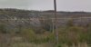
Snipped from US Army maps (1950s) of a small collective village Ivista, east of Belgorod.
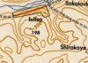
The same location from Google maps with terrain displayed.

The same area from Google overhead view. Please note that the top is covered in rows for grain with woods, brush, and open ground visible at the grain field edge. The red square is from where I snapped the pic from, looking down the ravine to the southeast.
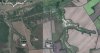
Here is looking up the ravine to the SE. I am not sure if this occurred across every battle fought on the steppe but giving the designer options allow for some terrain features and not just miles of rolling steppe by having a one hex gap.
IMO
Attachments
-
 56.3 KB Views: 11
Last edited:
Vinnie
See Dummies in the index
3-4 mapboards, 10 to 15 scenarios. Sounds like an action pack concept.
Bob Walters
Senior Member
It does not have to be of a scale that would show a full-scale battle. It just has to show give the flavor of what attacking and defending would be like in a balka or part of one.
Tom and I have done a number of Russian village ideas that, if added to some of these cool looking balka boards, could be an interesting group of boards. 3-4 well done Russian looking boards, one at least with a very Russian looking village, could be nice.3-4 mapboards, 10 to 15 scenarios. Sounds like an action pack concept.
Any scenario guys out there?
Creating the scenarios, considering the shortage of the necessary, tactical level, research material, of representative engagements may take considerably more time to produce than the boards.Tom and I have done a number of Russian village ideas that, if added to some of these cool looking balka boards, could be an interesting group of boards. 3-4 well done Russian looking boards, one at least with a very Russian looking village, could be nice.
Any scenario guys out there?
bprobst
Elder Member
- Joined
- Oct 31, 2003
- Messages
- 2,535
- Reaction score
- 1,441
- Location
- Melbourne, Australia
- First name
- Bruce
- Country
-

It is impossible to have an "overly-narrow interpretation of the terrain rules". You're either following the rules, or you're not. There isn't anything to "disagree" about. If you don't want to play by the rules, then I'm not interested in being your opponent, nor do I have much interest in what you might have to say about how maps are designed. How can you design an ASL map if you don't know how the rules work? (I'm not saying that the existing rules are always the best possible expression of a concept. The marsh rules break my heart almost every time I read them. I'm entirely OK with errata to fix the weirdnesses. In the absence of such errata, though, the rules are what we have to work with.)I strongly contend that anybody who doesn't see those Gullies as Gullies is taking an overly-narrow interpretation of the terrain rules.
That's not just directed at Tom -- many "amateur" ASL maps are designed by people who don't know how the rules work. Fortunately, the folks at MMP do know and (usually) catch the problems before the map ever sees print.
Tuomo
Keeper of the Funk
Um. Where? I thought I did those correctly.Fix those Crest Lines.
footsteps
Just visiting
If you're doing a River, you've done it perfectly. If it's a Valley, the Crestline should be on the other side of the hexsides.Um. Where? I thought I did those correctly.