Attention Mapmakers: Soviet villages

Proff3RTR

Elder Member
Joined
Jun 15, 2014
Messages
4,270
Reaction score
597
Location
Cornwall
Country
llUnited Kingdom
desert and steppe scenarios are a bit of an acquired taste......not shared by many East Front lovers.......and not so many accounts of major clashes on open steppe terrain, as far as I know.

In truth boards such as you find in CoS and some of the examples shown on this thread will do for Steppe terrain, as has already been said, no one wants to really play on terrain that is sooooooooooooo open.
 

Attachments

hayesncsu

Member
Joined
Oct 22, 2012
Messages
163
Reaction score
135
Location
North Carolina
First name
Hayes
Country
llUnited States
Other than some tank engagements was their fighting on this open of terrain? Or did the fighting occur around the more "defensible" locations? I envision these areas as mostly transit areas between locations of battles but certainly may be wrong. I know at Kursk and other locations the Soviets built fortifications.
 

Michael Dorosh

der Spieß des Forums
Joined
Feb 6, 2004
Messages
15,733
Reaction score
2,765
Location
Calgary, AB
First name
Michael
Country
llCanada
Other than some tank engagements was their fighting on this open of terrain? Or did the fighting occur around the more "defensible" locations? I envision these areas as mostly transit areas between locations of battles but certainly may be wrong. I know at Kursk and other locations the Soviets built fortifications.
Even on the Steppe, I suspect there would be very small unit actions - contact patrols, reconnaissance, etc. I'm not sure a village in this terrain was advantageous to a defender (I'd think occupying a wooden shack would only advertise your presence without providing much in the way of either concealment or cover), the way one of those huge gullies (balka) might be. I live on the prairies here in Canada, similar I think to the Steppe - and you're talking hundreds of kilometres of wide open spaces with very little vegetation and few trees - tactical problems not unlike the desert. In fact, as Perry might tell you, the British Army come to Canada to train in desert warfare exactly because the open, rolling terrain here is so similar.

https://history.army.mil/html/books/104/104-5/CMH_Pub_104-5.pdf

Link is to the US Army publication "Terrain Factors in the Russian Campaign."

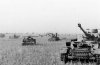
In that completely open terrain, every horse- 91' tractor-drawn gun was plainly visible over a considerable distance. Horses and motorized equipment were blown to bits by strafing aircraft, and the last few prime movers only succeeded under cover of darkness in towing away some of the guns. The rest had to be blown up. A few squadrons of German fighter aircraft could have saved a substantial part of the artillery, prime movers, and motor vehicles from destruction at the hands of Russian combat aviation.

The school solution, of course, would be to conduct major retrograde movements across steppe land only at night. In theory that solution sounds fine but in practice it is only possible if the defender succeeds in holding his position throughout the entire day until nightfall.

If the attacker gains ground during the day, or if a breakthrough becomes imminent or actually succeeds, the defender is unable to avoid large-scale movements during daylight hours. If the retiring defender lacks equality of airpower, not even the best organized dispersal of his units or the most artful camouflage will save him from his fate. The individual can always conceal himself with steppe grass, the sole but abundant camouflage material in that terrain.

A moving gun, a prime mover, or a column of trucks carrying reserves, however, cannot be concealed in the open steppe land, not even with a multitude of camouflage nets.

One of the major problems during combat in the arid steppe is a proper supply of drinking water. Each unit must have its own water truck. No less important are a number of other factors peculiar to that type of terrain. Except for the Balkas, the steppe offers no natural cover against air attack or artillery fire, so that bombs and shells have a particularly serious fragmentation effect. During prolonged halts motor vehicles had to be dug in. But some of the most severe hardships in the steppe result from the shortage of wood.

'Without wood, no fires can be built in the field kitchens and no shelters constructed. In the steppe, wood becomes a highly treasured ommodity, above all in the winter.

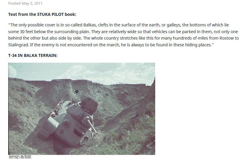
Winters in the steppe are rigorous. Neither forests nor mountains break the icy east wind or bank the snow. The wind whips the snow across the plains and into the only large depressions, the Balkas.

The Balkas, however, are the only places that offer shelter for men and vehicles. The result is a never-ending struggle against the drifting snow. Without well-regulated and ample shipments of heating fuel, a military force cannot survive a winter in the steppe. White camouflage clothing and white paint for vehicles are indispensable. The thaw radically changes the face of the steppe. The Balkas churn with swelling streams. Small depressions are transformed into ponds, and large areas of flatland are covered with water. The thawed ground becomes soggy; the muddy season begins. For a period of weeks neither troop convoys nor individual vehicles can move for any but the shortest distances. Only tracked vehicles are able to drag themselves through the mire.

Summertime in the steppe exposes a military force to yet another hazard-deliberately set fires. In the summer of 1942 the Russians repeatedly put the dry steppes to the torch. Fortunately, the fires never assumed such proportions that the troops were in bodily danger; they only ",ere forced to a rapid change of position. Nevertheless, the flames destroyed ammunition and equipment that could not be promptly evacuated. There is room for doubt, though, whether the Russians ever were bent on starting full-fledged conflagrations, even at places at which their aircraft dropped phosphorus. These scatterings
of incendiaries were more iIi the nature of local, uncoordinated nuisance raids, but the possibility of setting large-scale steppe fires with wholly different results is not to be ignored.

Finally, the steppe is ideally suited for parachute and air landing operations on even the largest scale. The terrain offers completely unobstructed landing facilities for glider and transport aircraft. But neither the Germans nor the Russians took advantage of that opportunity during World War II.

Image is from a BGG discussion. Balkas can actually be much deeper and wider than this - and probably not well illustrated by the current geo boards, though board 11 might come close - particularly if you SSR the hill hexes to be a Level -1 valley (or Board 24, if one removes the buildings....and trees....) - kind of a long strip of Level -1 terrain. Driving from Calgary to Edmonton, there is a very fine example of at least one on the Queen Elizabeth II Highway, just east of the roadway. I'll see if I can find the Google Street view of it.

balka2.jpg
Not a great view, and maybe more of an escarpment or a canyon than a true balka, but I always think of Stalingrad when I drive past. You can see the gentle slope into the bottom land. You could hide a battalion in here from direct observation, but as the book extract says, all the camo nets in the world wouldn't be able to hide a battery of guns from an enemy observation plane. I expect air superiority was very important, and so were anti-aircraft units.
 
Last edited:

RandyT0001

Elder Member
Staff member
Administrator
Moderator
Joined
Dec 5, 2016
Messages
1,055
Reaction score
1,273
Location
Memphis, TN
First name
Cary
Country
llUnited States
Even on the Steppe, I suspect there would be very small unit actions - contact patrols, reconnaissance, etc. I'm not sure a village in this terrain was advantageous to a defender (I'd think occupying a wooden shack would only advertise your presence without providing much in the way of either concealment or cover), the way one of those huge gullies (balka) might be. I live on the prairies here in Canada, similar I think to the Steppe - and you're talking hundreds of kilometres of wide open spaces with very little vegetation and few trees - tactical problems not unlike the desert. In fact, as Perry might tell you, the British Army come to Canada to train in desert warfare exactly because the open, rolling terrain here is so similar.

https://history.army.mil/html/books/104/104-5/CMH_Pub_104-5.pdf

Link is to the US Army publication "Terrain Factors in the Russian Campaign."


Image is from a BGG discussion. Balkas can actually be much deeper and wider than this - and probably not well illustrated by the current geo boards, though board 11 might come close - particularly if you SSR the hill hexes to be a Level -1 valley (or Board 24, if one removes the buildings....and trees....) - kind of a long strip of Level -1 terrain. Driving from Calgary to Edmonton, there is a very fine example of at least one on the Queen Elizabeth II Highway, just east of the roadway. I'll see if I can find the Google Street view of it.

Not a great view, and maybe more of an escarpment or a canyon than a true balka, but I always think of Stalingrad when I drive past. You can see the gentle slope into the bottom land. You could hide a battalion in here from direct observation, but as the book extract says, all the camo nets in the world wouldn't be able to hide a battery of guns from an enemy observation plane. I expect air superiority was very important, and so were anti-aircraft units.
So, a new overlays are needed to (attempt) to address these stretches of depression. One could also use river boards as a substitute (without the water) to stretch the balka for several kilometers or placed between normal open terrain and/or desert terrain boards as a obstacle. We need to find historical accounts. Some of these collective villages were built in the wider balka (around Voronezh) and we will need that map board as well.
 

RandyT0001

Elder Member
Staff member
Administrator
Moderator
Joined
Dec 5, 2016
Messages
1,055
Reaction score
1,273
Location
Memphis, TN
First name
Cary
Country
llUnited States
Other than some tank engagements was their fighting on this open of terrain? Or did the fighting occur around the more "defensible" locations? I envision these areas as mostly transit areas between locations of battles but certainly may be wrong. I know at Kursk and other locations the Soviets built fortifications.
The Russians kept detailed reports of their battles. Russians do not subscribe to the western idea that the operational level of combat is an art and a science, merely a science to be studied and mastered. Glantz and others have been able to translate and write books about some of the major (and several less well known battles) but rarely provide tactical level recounts of action like we need for ASL (IMO).
 

Michael Dorosh

der Spieß des Forums
Joined
Feb 6, 2004
Messages
15,733
Reaction score
2,765
Location
Calgary, AB
First name
Michael
Country
llCanada
The German histories that have been translated into English seem to center on regimental and divisional level. While there are sometimes some good vignettes from personal accounts, they also don't concern themselves much with tactical level stuff. And worst of all, they usually don't even bother to identify things like enemy unit identifications, strength, compositions. One suspects they were researched from AARs that might have some of those things, but the historians don't seem to have thought it would be of interest, or perhaps appropriate for the level of discussion they were presenting. But - I may simply be reading the wrong books. The US Army's manual on small unit actions in the Russian Campaign is a nice counterpoint to that, but perhaps gets mentioned so much because of the rarity of finding such a collection of tactical accounts.
 

DWPetros

Senior Member
Joined
Sep 27, 2016
Messages
218
Reaction score
502
Country
llUnited States
I prepared Board 69, and yes, that was largely the intent.

There are other sketches too - and I couldn't agree more that we need more Russian/Ukrainian looking terrain.

1531344127358.png
 

Robin Reeve

The Swiss Moron
Staff member
Moderator
Joined
Jul 26, 2003
Messages
19,636
Reaction score
5,613
Location
St-Légier
First name
Robin
Country
llSwitzerland
Were tanks able to take hull down positions in a balka - quite like with wadis?
In that case, there could be some combined Valley and Gully terrain (to depict the fact that getting hull down positions was not always possible) - an SSR granting Gullies Wadi proprieties.
 

tailesin

Member
Joined
Jan 28, 2013
Messages
75
Reaction score
32
Location
Barcelona Catalunya
Country
llSpain
Boys, I've found very interesting this discussion about Russian-Ukranian villages and terrain in general. I like some of the designs shown and really would like to see them in future prints. I also look forward Don's Ponyri map and module. Hope soon !!!

I think we asl players and you designers are too village-objective centered. Even though many times both axis and allies had towns or villages as their objective, specially on the russian front in winter, many times the objective was to control that rise or balka or ford that was important for further advance or to direct artillery fire, etc

Reading about the german advance during 1942 and combat during 43 you will see that many fighting took place out of big towns or even villages. With plenty of combat to take a not so high rise (like the combats of Mius in 43) surrounded by Balkas and sunflower fields, or just from balka to balka during the advance to stalingrad or from rise to rise around Teploye during kurks. I've recently read of an episode during the 42 advance to the Don river when a batalion of german gebirjaegers (mountain trops) are surprissed advancing on the stepe by the russians surging from a balka and simply destroyed as a fighting unit by the russian tanks. (and are the germans who tell that)... you can find many more examples of combat where high points or woods are the objective not villages..

So yes!! We need some boards to represent better Ukranian flats and balkas, rises, little woods....and why not allow for some long range firing.
 

Paul M. Weir

Forum Guru
Staff member
Moderator
Joined
Apr 3, 2004
Messages
8,706
Reaction score
3,732
Location
Dublin
First name
Paul
Country
llIreland
Were tanks able to take hull down positions in a balka - quite like with wadis?
In that case, there could be some combined Valley and Gully terrain (to depict the fact that getting hull down positions was not always possible) - an SSR granting Gullies Wadi proprieties.
Never having taken a hiking trip in Ukraine, I have to rely on photographs. As far as I can figure out Balkas and Wadis have the same source, inundation and erosion due to high volume seasonal rain. Due to the different climate the Wadis get flooded far less often. In addition in the Western Desert the underlying ground is mainly solid stone whilst in the Ukraine it's soil, often very deep. So in general the Balkas are much deeper and wider, though some will be little more than glorified drainage ditches. I have see photos of what looked like battalion+ sized units quite happily sheltering there with little crowding.

As for cross section, most have gently sloping centre floors with steep sides, sometimes partly undercut but with reasonably frequent and passible side breaks, whether human worn or flood worn. Many that I noted were well able to hide even the biggest AFV, the lip sometimes being two or three times the AFV height. You could think of them as medium to major sized rivers, but being seasonal, not having the time that a river has to get its shit together, a disorganised river bed.

So in summary, everything from a glorified drainage ditch to a big steep sided valley with from few to frequent exit points (hull down locations). Photos are your best guide.
 

Paul M. Weir

Forum Guru
Staff member
Moderator
Joined
Apr 3, 2004
Messages
8,706
Reaction score
3,732
Location
Dublin
First name
Paul
Country
llIreland
In other words, a big (deep) balka is a valley hex.
It can be quite big, like a valley but often with quite steep or cliff style sides. I think of an ASL valley as being the inverse of a hill, more often gentle to moderate slopes, any awkward to climb bits in general being below the ASL scale, the bad bits that are would be the rare cliff hexsides. Though you do have some double crestlines in ASL they are rare until the 80-83 boards came out in FW. The smaller balkas are covered fairly well with ASL's gullies, but a bigger one would have to treat many of its single elevation change crestlines more like a double elevation change for rules purposes.

At least that's my interpretation of them. YMMV.
 

RandyT0001

Elder Member
Staff member
Administrator
Moderator
Joined
Dec 5, 2016
Messages
1,055
Reaction score
1,273
Location
Memphis, TN
First name
Cary
Country
llUnited States
Paul,

What we need is -1 level overlays for all of the river boards with some intersecting and stand alone -1 level overlays to create the gully to balka branches. Some branches and some 'extra' -1 level hexes have roads printed on them so that roads can transition into the former river valleys. Also need one -1 level board of overlays representing the start or box end of a balka.
 

Paul M. Weir

Forum Guru
Staff member
Moderator
Joined
Apr 3, 2004
Messages
8,706
Reaction score
3,732
Location
Dublin
First name
Paul
Country
llIreland
Paul,

What we need is -1 level overlays for all of the river boards with some intersecting and stand alone -1 level overlays to create the gully to balka branches. Some branches and some 'extra' -1 level hexes have roads printed on them so that roads can transition into the former river valleys. Also need one -1 level board of overlays representing the start or box end of a balka.
That would work for the ones with more eroded sides. The valley-gulley join overlays are also a good idea.

From a rules/play perspective, for some balkas a good chunk of the crest lines would be difficult or impassible to vehicles, difficult for horses (might have to be led on foot), but not too bad for SMC/MMC (definitely not cliffs for foot traffic purposes) . About the only thing I can think of is to treat the crest line as a double elevation change and put "Trailbreak" counters where there are places where vehicles could climb out of. I'm sure others can think of better ways of depicting that type of balka. That difficult type would not be the case for all balkas, a study of photos and personal judgement of their passibility being the main guide.
 
Last edited:

DWPetros

Senior Member
Joined
Sep 27, 2016
Messages
218
Reaction score
502
Country
llUnited States
To really represent these open Russian plains and balkas well, I think you'd need a number of boards to do this - like with the Desert boards. They would look sort of like our regular boards, with lots of green, Level -1, maybe even Level +1, but otherwise pretty featureless. That our current mix of boards have all those roads (I, Q, Y), the designer is almost forced to include those roadways in order to make them geomorphic. You'd need to ignore using all those roads, use maybe only 1 roadway, and keep it pretty blank otherwise. I think it's a great idea to have about 3-4 of those kind of boards around.
 

horseshoe

Senior Member
Joined
Dec 12, 2011
Messages
3,379
Reaction score
287
Location
Memphis, Tn
Country
llUnited States
To really represent these open Russian plains and balkas well, I think you'd need a number of boards to do this - like with the Desert boards. They would look sort of like our regular boards, with lots of green, Level -1, maybe even Level +1, but otherwise pretty featureless. That our current mix of boards have all those roads (I, Q, Y), the designer is almost forced to include those roadways in order to make them geomorphic. You'd need to ignore using all those roads, use maybe only 1 roadway, and keep it pretty blank otherwise. I think it's a great idea to have about 3-4 of those kind of boards around.
SSR 2, No roads exist, treat as other terrain in hex.
 

RandyT0001

Elder Member
Staff member
Administrator
Moderator
Joined
Dec 5, 2016
Messages
1,055
Reaction score
1,273
Location
Memphis, TN
First name
Cary
Country
llUnited States
Something like this stuck on the end of board 7, SSR the islands out (or make a one or two mounds of open ground level 0). SSR the swamp to open ground level 0.
(This is a very rough outline to present the idea.)

MMPx Balka River end Overlay.jpg
 

DWPetros

Senior Member
Joined
Sep 27, 2016
Messages
218
Reaction score
502
Country
llUnited States
I'm not a big fan of using boards where we need to pretend that one feature is either not there or is something else. I also don't like ugly overlays that might be technically functional, but look, well, ugly.
Making new boards isn't hard - the design work is easy, the cost is relatively inexpensive, and given that we don't need to buy any other components (we have all the counters and rules) - what's left to add to our collection than new boards? Not much, so let's do some new boards and do it right.
 
Top