ASL levels vs actual topographical height from maps

apbills

Elder Member
Joined
Jan 28, 2003
Messages
3,423
Reaction score
955
Location
Pewaukee, WI
Country
llUnited States
I am looking at diving into making an ASL map from a topographical map I have of an area of interest. What rules of thumb does anyone have regarding levels? I do not have the stoumont area topographical map so can not compare how they did it in that area.

Any help?
 

jrv

Forum Guru
Joined
May 25, 2005
Messages
21,998
Reaction score
6,207
Location
Teutoburger Wald
Country
llIceland
The best guess is somewhere around 10 meters per level for a generic map, but it's all very design-for-effect. My estimate on KGP was around 20 meters per level. Something set in Norway might be more. Something in town might be less, with each building level showing up as one, say 3-4 meter, level. Each ASL level could also represent several building levels. Or not. Edson's Ridge has four levels, and the height of the hill is 100 feet. That's 25 feet/level.

JR
 

Carln0130

Forum Guru
Joined
Mar 25, 2006
Messages
5,996
Reaction score
2,621
Location
MA
Country
llUnited States
I am looking at diving into making an ASL map from a topographical map I have of an area of interest. What rules of thumb does anyone have regarding levels? I do not have the stoumont area topographical map so can not compare how they did it in that area.

Any help?
As J.R. implies, it's pretty variable. Note the heights and undulations and calculate out how you best feel it fits your design. It's much like the time scale in the game. Technically it is two minutes per turn, but there are scenarios where it represents far more than that, clearly, to say nothing of CG's. It design for effect, so get the way the surrounding heights correspond militarily and convert them into ASL in a way that feels right, given the situation. It doesn't have to be an exact translation, it seldom is.
 

Paul M. Weir

Forum Guru
Staff member
Moderator
Joined
Apr 3, 2004
Messages
8,706
Reaction score
3,732
Location
Dublin
First name
Paul
Country
llIreland
CH, many years ago, when adopting their ATS maps for ASL, left the 10m contour labels on. So CH choose that as a standard and it's the only case I know of where there was a direct ASL level to physical height comparison.

I see an ASL level as enough to well mask a human, Gun or vehicle, so anything from 3-4m to whatever you wish. As long as building height to hill level height are proportional and realistic then that's fine. The same board could represent low rolling but sight blocking hills or decently high hills, depending upon scenario.
 

Rubrik

Member
Joined
Apr 12, 2017
Messages
62
Reaction score
10
Country
ll
I am looking at diving into making an ASL map from a topographical map I have of an area of interest. What rules of thumb does anyone have regarding levels? I do not have the stoumont area topographical map so can not compare how they did it in that area.

Any help?
I have one of the LFT journals and there is an article about a topography software - they have a hex superimposed on an air fot. I went to France recently and saw some huge hills, abrupt level changes with a house or two covered in forest at the top. I have not seen this type of map in the system.
 

Rubrik

Member
Joined
Apr 12, 2017
Messages
62
Reaction score
10
Country
ll
IMG_0119.JPG
CH, many years ago, when adopting their ATS maps for ASL, left the 10m contour labels on. So CH choose that as a standard and it's the only case I know of where there was a direct ASL level to physical height comparison.

I see an ASL level as enough to well mask a human, Gun or vehicle, so anything from 3-4m to whatever you wish. As long as building height to hill level height are proportional and realistic then that's fine. The same board could represent low rolling but sight blocking hills or decently high hills, depending upon scenario.
Paul, what level would you say this hill is? At first I said level 2 but it dwarfs the level 2 buildings
 

RandyT0001

Elder Member
Staff member
Administrator
Moderator
Joined
Dec 5, 2016
Messages
1,055
Reaction score
1,273
Location
Memphis, TN
First name
Cary
Country
llUnited States
I am looking at diving into making an ASL map from a topographical map I have of an area of interest. What rules of thumb does anyone have regarding levels? I do not have the stoumont area topographical map so can not compare how they did it in that area.

Any help?
http://www.lib.utexas.edu/maps/ams/belgium_50k/txu-pclmaps-oclc-6624543-malmedy-81.jpg

Lower left corner has Stoumont.

I am willing to help create the map. If you tell me the specific location of you interest area I could start a basic map with Hexdraw.
 

Rubrik

Member
Joined
Apr 12, 2017
Messages
62
Reaction score
10
Country
ll
View attachment 1943

This is my interruption of the hill in ASL terms.
The little houses by the lighthouse have a ground and 1st floor (or is that US? Well 1st and 2nd Floor). The light house has a spire equivalent agreed but it's height is deceptive. The other buildings also have a ground and 1st floor which makes them level two. The hill has a very gradual slope that mught only be seen on KGP so I'm not really sure
 

jrv

Forum Guru
Joined
May 25, 2005
Messages
21,998
Reaction score
6,207
Location
Teutoburger Wald
Country
llIceland
Because of the gradual slope the buildings all have LOS from/to the lower parts of a potential map. I think you have two choices: make the crest line near the buildings or use slopes. I am not sure if a level two section is appropriate either; it looks as though the ground level locations on the upper part of the hill will be plateau-ed when looking over the lower part of the hill.

JR
 

apbills

Elder Member
Joined
Jan 28, 2003
Messages
3,423
Reaction score
955
Location
Pewaukee, WI
Country
llUnited States
Great input from all.

Don't know if you guys know of this resource, but the maps on this site are very useful for areas within Germany. These are listed as pre-WWII, so I suspect they would be very close to reality in 44-45.

https://lib.byu.edu/collections/german-maps/

It does appear some of these were modified in the early 50's as well.
 
Last edited:

Paul M. Weir

Forum Guru
Staff member
Moderator
Joined
Apr 3, 2004
Messages
8,706
Reaction score
3,732
Location
Dublin
First name
Paul
Country
llIreland
I would agree with others that a 2 storey/floor (IE ground + 1 other) building is not always 2 ASL levels (level 0 + 1). If it's the only 2 storey building in a village of squat but substantial ground floor only buildings on fairly level grounds, then it might be worth 2 ASL levels, but in a town of many such buildings that has some higher office and factory blocks then it might be better represented by a single level.

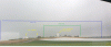
As for the photo, I would agree with RandyT0001 with the hill heights. The lighthouse like building I, however, would rate as a level 2 with either a steeple or rooftop location in addition to the 2 levels. I can only guess its function, given the lower silo like adjacent buildings, it might be a grain drying building and thus be classed as an ASL Factory and though 2 levels high would only have a ground and rooftop location in ASL.

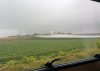
That brings me to another question. While the above photo is very slightly canted anti-clockwise and thus giving a slightly skewed version of what is 'level', it illustrates the problem. You can have slightly sloped ground that has an almost flat and constant slope. Say we take a board lengthwise. One end is at 100m above sea level, the other end is 130m, IE a change of 3 ASL levels over the whole board length. My approach would be to ignore such a slope as while you might notice it when cycling fast either direction, on foot or on a vehicle you would barely notice it. Only the intervening small hills, hollows, hedges and buildings would be of significance in combat, not that there is a constant rise over a board length. That's something to be adjusted for when translating from a topographical map to an ASL board.
 

jrv

Forum Guru
Joined
May 25, 2005
Messages
21,998
Reaction score
6,207
Location
Teutoburger Wald
Country
llIceland
Depending on the rest of the terrain, you could make a good case for not having any hill at all. If there is nothing but open ground in the area where the photograph was taken from and the attack came from there, you don't really gain that much by adding a hill. I'm not sure the Height Advantage DRM should really be applied here. But again, design for effect.

JR
 

Robin Reeve

The Swiss Moron
Staff member
Moderator
Joined
Jul 26, 2003
Messages
19,646
Reaction score
5,630
Location
St-Légier
First name
Robin
Country
llSwitzerland
And vehicles hardly could maneuver to get in a HD position...
 

Rubrik

Member
Joined
Apr 12, 2017
Messages
62
Reaction score
10
Country
ll
Any elevation will give you hull down regardless of how acute or gentle the gradient. Thats basic maths. The question is the degree of HD and the fields of fire.
 

Yuri0352

Elder Member
Joined
Nov 21, 2014
Messages
2,150
Reaction score
1,221
Location
25-30 Hexes
Country
llUnited States
And vehicles hardly could maneuver to get in a HD position...
I'm not so sure about that...

I've seen a few M-60 tank crews who managed to go HD in desert terrain more subtle than the slope in that photograph.
 

jrv

Forum Guru
Joined
May 25, 2005
Messages
21,998
Reaction score
6,207
Location
Teutoburger Wald
Country
llIceland
I'm not so sure about that...

I've seen a few M-60 tank crews who managed to go HD in desert terrain more subtle than the slope in that photograph.
There are histories that I have read that said that when the 7th Armored (the Desert Rats) got to Normandy, most of their desert veterans were no longer with the unit. It was noticeable that whereas in North Africa if there was a slight dip in the ground (a dier or similar) the 7th Armored tank would be in it, while in Normandy the tanks of the 7th Armored would wander around oblivious to obvious terrain, never mind subtle ones. As much as a matter of the availability of useable terrain it is also a function of crew training.

JR
 
Top